Pilgrimage routes
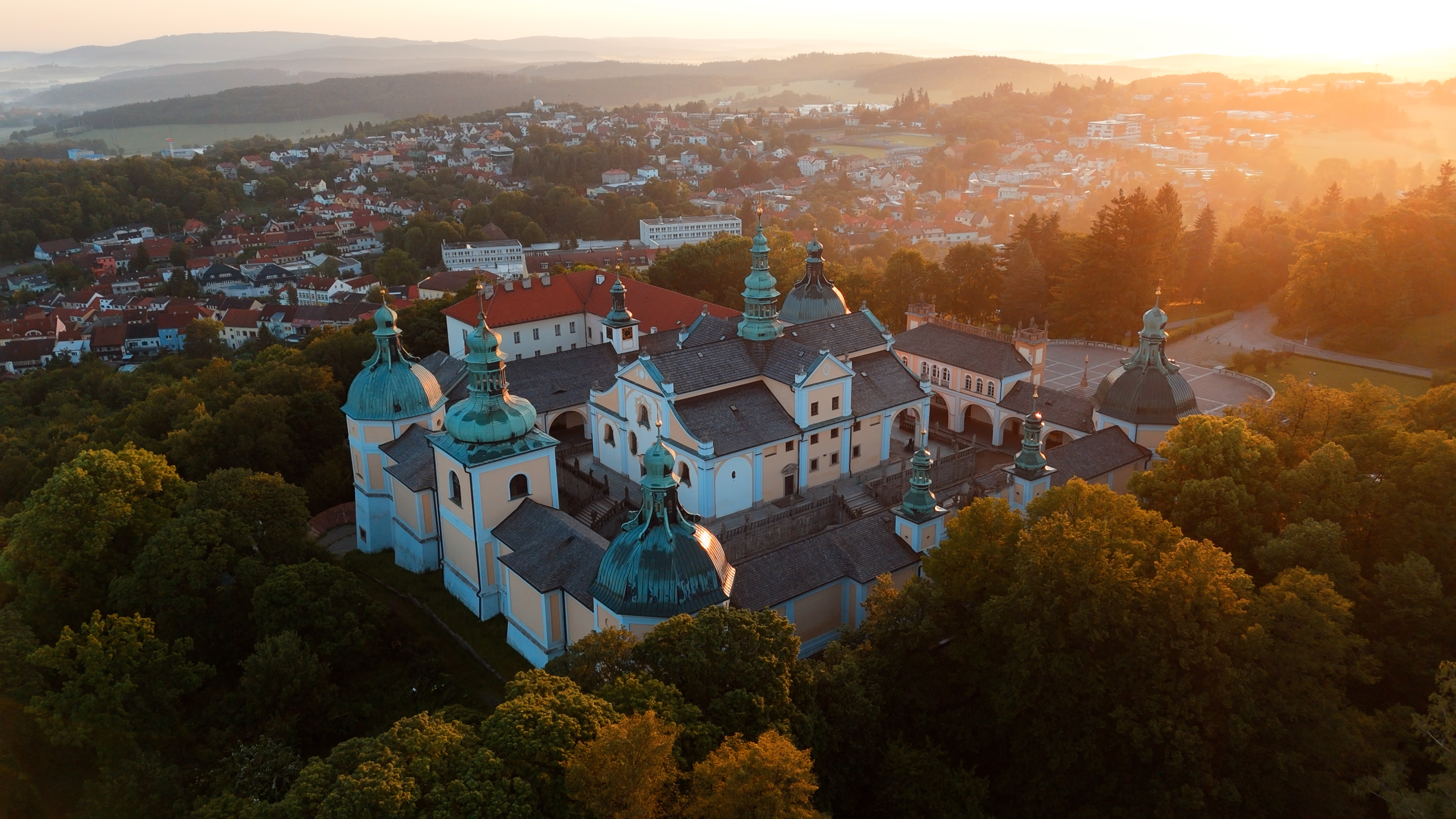
The pilgrimage to Svatá Hora near Příbram is one of the oldest and liveliest spiritual traditions in Bohemia. For centuries, pilgrims have walked here, often from great distances, to ask for help, give thanks or seek inner peace. The pilgrimage was not just a journey through space, but above all a journey of inner transformation, silence and prayer. Each step had its own meaning and physical exertion was seen as part of a spiritual sacrifice. The Holy Mountain was seen as a place of special closeness to God and the Virgin Mary, where one came with an open heart. Traditional pilgrimages took place on Marian feasts, but pilgrims also came individually throughout the year. The paths led through the countryside, villages and forests, forming a natural network of spiritual arteries linking the regions. The pilgrimage promoted the meeting of people, the sharing of faith and human stories. Even today, pilgrimage traditions are being renewed and taking on a new dimension - reaching out to believers, seekers and those who want to slow down and step out of the hustle and bustle of everyday life. Svatá Hora thus remains a destination where the past naturally meets the present. The pilgrimage route here becomes not just a journey to a place, but a journey to oneself.
In the coming years, with your help, we would like to prepare several walking pilgrimage routes from different parts of the country, so that the pilgrimage to Svatá Hora becomes a Czech Camino. If you would like to participate in the creation of this project, please write to basilica@farnost-svatahora.cz. Here is an overview of the most famous pilgrimage (walking) routes. Neither of them is specially marked yet, you can be the first to support this project by completing it and preparing it for others.
The routes are ordered approximately by length.
<!-- 1 --> <details class="accordion"> <summary>1. BŘEZNICE ROUTE</summary> <p> <b>Březnice - Chrást - Třebsko - Příbram - Svatá Hora</b><br> <b>Short history:</b><br> One of the oldest historically documented pilgrimage routes to Svatá Hora. As early as the 17th century it was equipped with stops and served mainly parish and regional pilgrimages from Březnice.<br><br> <b>Length:</b> 20.5 km<br> <b>Elevation:</b> moderate<br><br> <b>Number of days:</b> 1<br><br> <b>Stages:</b><br> Březnice - Chrást ...... 4,8 km<br> Chrást - Třebsko ...... 4 km<br> Třebsko - Příbram ...... 10,4 km<br> Příbram - Svatá Hora ...... 1,3 km<br><br> <b>Most interesting points:</b> Březnice Castle, preserved and commemorated stops of the pilgrimage route, historical landscape of Podbrdsko, ceremonial arrival to Svatá Hora<br> <b>Places to stay:</b> Březnice (guesthouses - rather rarely needed), Příbram, Svatá Hora<br> <b>Challenges:</b> not always clear historical route guidance<br><br> <a href="https://mapy.com/s/mujerejedo" target="_blank" rel="noopener noreferrer">link to maps</a> <!-- TODO: insert image of route map --> </p> </details> <!-- 2 --> <details class="accordion"> <summary>2. BRDSKÁ / DOBŘÍŠÁ ROUTE</summary> <p> <b>Dobříš - Voznice - Háje - Příbram - Svatá Hora</b><br><br> <b>Short history:</b><br> Traditional regional access from Dobříš region through Brdy, used by individuals and groups, now popular for day or night pilgrimages.<br><br> <b>Length:</b> 47.8 km<br> <b>Elevation:</b> significantly undulating terrain<br><br> <b>Number of days:</b> 2-3 days<br><br> <b>Stages:</b><br> Dobříš - Voznice ...... 7.4 km<br> Voznice - Háje ...... 34.1 km<br> Háje - Příbram ...... 5 km<br> Příbram - Svatá Hora ...... 1.3 km<br><br> <b>Highlights:</b> Brda forests, Dobříš Castle, Skalka u Dobříše, quiet natural landscape of Podbrdsko<br> <b>Places to stay:</b> Dobříš, Příbram / Svatá Hora<br> <b>Disadvantages:</b> long forest stretches without services<br><br> <a href="https://mapy.com/s/datupevagu" target="_blank" rel="noopener noreferrer">link to maps</a> <!-- TODO: insert image of route map --> </p> </details> <!-- 3 --> <details class="accordion"> <summary>3. MILEVSKÁ TRASA</summary> <p> <b>Milevsko - Sedlčany - Příbram - Svatá Hora</b><br><br> <b>Short history:</b><br> One of the traditional South Bohemian pilgrimage routes, also suitable for weekend pilgrimage.<br><br> <b>Length:</b> approx. 76.5 km<br> <b>Elevation:</b> moderate<br><br> <b>Number of days:</b> 3<br><br> <b>Stages:</b><br> Milevsko - Sedlčany ...... 34,9 km<br> Sedlčany - Příbram ...... 40,4 km<br> Příbram - Svatá Hora ...... 1,3 km<br><br> <b>Most interesting points:</b> Milevsko Monastery, Sedlčany, gradually approaching Brdy<br> <b>Places to stay:</b> Milevsko, Sedlčany, Příbram<br> <b>Challenges:</b> longer and physically continuous stages<br><br> <a href="https://mapy.com/s/dabavadalu" target="_blank" rel="noopener noreferrer">link to maps</a> <!-- TODO: insert image of route map --> </p> </details> <!-- 4 --> <details class="accordion"> <summary>4. PÍSEKÁ TRASA</summary> <p> <b>Písek - Milevsko - Sedlčany - Příbram - Svatá Hora</b><br><br> <b>Short history:</b><br> The route starts from the historical town of Písek, connecting the South Bohemian spiritual centres with Příbram.<br><br> <b>Length:</b> 110.5 km<br> <b>Elevation:</b> moderate<br><br> <b>Number of days:</b> 4-5<br><br> <b>Stages:</b><br> Písek - Milevsko ...... 33,9 km<br> Milevsko - Sedlčany ...... 34,9 km<br> Sedlčany - Příbram ...... 40,4 km<br> Příbram - Svatá Hora ...... 1,3 km<br><br> <b>Most interesting points:</b> the stone bridge in Písek, the South Bohemian landscape, the Milevsko monastery<br> <b>Places to stay:</b> Písek, Milevsko, Sedlčany, Příbram<br> <b>Challenges:</b> open countryside<br><br> <a href="https://mapy.com/s/kupupanune" target="_blank" rel="noopener noreferrer">link to maps</a> <!-- TODO: insert image of route map --> </p> </details> <!-- 5 --> <details class="accordion"> <summary>5. THE PRAGUE ROUTE</summary> <p> <b>Prague - Zbraslav - Mníšek pod Brdy - Dobříš - Příbram - Svatá Hora</b><br><br> <b>Short history:</b><br> The most natural direction from the capital, today partially connected with the St.<br><br> <b>Length:</b> 78.2 km<br> <b>Elevation:</b> medium (Brda ridges)<br><br> <b>Number of days:</b> 4<br><br> <b>Stages:</b><br> Prague - Zbraslav ...... 15,7 km<br> Zbraslav - Mníšek pod Brdy ...... 22,6 km<br> Mníšek pod Brdy - Dobříš ...... 13,5 km<br> Dobříš - Příbram - Svatá Hora ...... 26,4 km<br><br> <b>Most interesting points:</b> Zbraslav Monastery, Brdy ridges, Skalka u Mníšku, Dobříš Castle, panoramic approach to Příbram<br> <b>Places to stay:</b> Zbraslav (guesthouses), Mníšek p. Brdy, Dobříš, Příbram / Svatá Hora<br> <b>Challenges:</b> long forest stretches without services, mud after rain<br><br> <a href="https://mapy.com/s/celapamuze" target="_blank" rel="noopener noreferrer">link to maps</a> <!-- TODO: insert image of route map --> </p> </details> <!-- 6 --> <details class="accordion"> <summary>6. BENEŠOV / SÁZAV ROUTE</summary> <p> <b>Sázava - Benešov - Sedlčany - Příbram - Svatá Hora</b><br><br> <b>Short history:</b><br> A direction following the tradition of the Sázava Monastery and the pilgrimage Posázaví.<br><br> <b>Length:</b> 102.4 km<br> <b>Elevation:</b> medium<br><br> <b>Number of days:</b> 4<br><br> <b>Stages:</b><br> Sázava - Benešov ...... 27,3 km<br> Benešov - Sedlčany ...... 33,4 km<br> Sedlčany - Příbram ...... 40,4 km<br> Příbram - Svatá Hora ...... 1,3 km<br><br> <b>Most interesting points:</b> Sázava Monastery, Posázaví region, churches and small sacral monuments of Benešov region<br> <b>Places to stay:</b> Sázava, Benešov, Sedlčany, Příbram<br> <b>Challenges:</b> undulating terrain<br><br> <a href="https://mapy.com/s/gavevagake" target="_blank" rel="noopener noreferrer">link to maps</a> <!-- TODO: insert image of route map --> </p> </details> <!-- 7 --> <details class="accordion"> <summary>7. PLZEN ROUTE</summary> <p> <b>Plzeň - Zbiroh - Jince - Příbram - Svatá Hora</b><br> <b>Short history:</b><br> The Pilsen route represents the traditional arrival of pilgrims from western Bohemia and in modern times is one of the main routes of renewed long-distance pilgrimages to Svatá Hora.<br><br> <b>Length:</b> 86.2 km<br> <b>Elevation:</b> more challenging<br><br> <b>Number of days:</b> 4<br><br> <b>Stages:</b><br> Plzeň - Zbiroh ...... 43.3 km<br> Zbiroh - Jince ...... 23.4 km<br> Jince - Příbram ...... 18.1 km<br> Příbram - Svatá Hora ...... 1.3 km<br><br> <b>Most interesting points:</b> the town of Plzeň, the crossing of the Brda, the Jince ponds, the military landscape of the Brda, the gradual approach to Příbram<br> <b>Places to stay:</b> Plzeň, Zbiroh, Jince, Příbram/Svatá Hora<br> <b>Challenges:</b> need to respect protected area, mud after rains<br><br> <a href="https://mapy.com/s/najofufemu" target="_blank" rel="noopener noreferrer">link to maps</a> <!-- TODO: insert image of route map --> </p> </details> <!-- 8 --> <details class="accordion"> <summary>8. PELHŘIMOV ROUTE</summary> <p> <b>Pelhřimov - Milevsko - Sedlčany - Příbram - Svatá Hora</b><br><br> <b>Short history:</b><br> Traditional Highland pilgrimage route, suitable for quiet and discreet wandering.<br><br> <b>Length:</b> 171.2 km<br> <b>Elevation:</b> mild to moderate<br><br> <b>Number of days:</b> 11 <br><br> <b>Stages:</b><br> 1. Pelhřimov - Milevsko ...... 94.7 km<br> 2. Milevsko - Sedlčany ...... 34,9 km<br> 3. Sedlčany - Příbram ...... 40,4 km<br> 4. Příbram - Svatá Hora ...... 1.3 km<br><br> <b>Most interesting points:</b> sacral monuments of the Highlands, Milevsko, traditional South Bohemian landscape<br> <b>Places to stay:</b> Pelhřimov, Milevsko, Sedlčany, Příbram<br> <b>Challenges:</b> longer sections without refreshments<br><br> <a href="https://mapy.com/s/lazofamuse" target="_blank" rel="noopener noreferrer">link to maps</a> <!-- TODO: insert image of route map --> </p> </details> <!-- 9 --> <details class="accordion"> <summary>9. Vltava Route</summary> <p> <b>Prague - Zbraslav - Štěchovice - Kamýk nad Vltavou - Orlík - Příbram - Svatá Hora</b><br><br> <b>Short history:</b><br> Pilgrimage along the historic Vltava corridor, connecting the water landscape with the inland.<br><br> <b>Length:</b> approx. 110-120 km<br> <b>Elevation:</b> moderate to challenging (frequent elevation differences)<br><br> <b>Number of days:</b> 5<br><br> <b>Stages:</b><br> Prague - Zbraslav ...... 18 km<br> Zbraslav - Štěchovice ...... 20 km<br> Štěchovice - Kamýk nad Vltavou ...... 24 km<br> Kamýk nad Vltavou - Orlík ..... 22 km<br> Orlík - Příbram ...... 28 km<br> Příbram - Svatá Hora ...... 6 km<br><br> <b>Most interesting points:</b> Vltava River viewpoints, Slapská and Orlická reservoirs, historical villages of the Povltava River, contrast of the water landscape and the Brda Mountains<br> <b>Places to stay:</b> Zbraslav, Štěchovice, Kamýk nad Vltavou, Orlík / surroundings, Příbram<br> <b>Challenges:</b> significant elevations around the Vltava, physical demanding, hot in summer and limited shading<br><br> <!-- TODO: insert image of route map --> </p> </details> <!-- 10 --> <details class="accordion"> <summary>10. ŽELIV ROUTE</summary> <p> <b>Želiv - Pelhřimov - Milevsko - Příbram - Svatá Hora</b><br><br> <b>Short history:</b><br> The route starts from the important Premonstratensian monastery in Želiv and connects the Highlands with southern Bohemia.<br><br> <b>Length:</b> approx. 110 km<br> <b>Elevation:</b> medium<br><br> <b>Number of days:</b> 5<br><br> <b>Stages:</b><br> Želiv - Pelhřimov ...... 16 km<br> Pelhřimov - Kovářov ...... 22 km<br> Kovářov - Milevsko ...... 24 km<br> Milevsko - Příbram ...... 36 km<br> Příbram - Svatá Hora ...... 6 km<br><br> <b>Most interesting points:</b> Premonstratensian monastery Želiv, Highlands, Milevsko monastery, quiet rural landscape<br> <b>Places to stay:</b> Želiv / Pelhřimov, Kovářov (surroundings), Milevsko, Příbram<br> <b>Disadvantages:</b> fewer services in smaller villages<br><br> <!-- TODO: insert image of route map --> </p> </details> <!-- 11 --> <details class="accordion"> <summary>11. KUTNOHORA ROUTE</summary> <p> <b>Kutná Hora - Vlašim - Sedlčany - Příbram - Svatá Hora</b><br> <b>Short history:</b><br> The route is based on an important spiritual and cultural centre of medieval Bohemia. It connects the Posázaví and central Povltava regions.<br><br> <b>Length:</b> approx. 120 km<br> <b>Elevation:</b> moderate to moderate<br><br> <b>Number of days:</b> 5<br><br> <b>Stages:</b><br> Kutná Hora - Vlašim ...... 26 km<br> Vlašim - Trhový Štěpánov ...... 18 km<br> Trhový Štěpánov - Sedlčany ..... 22 km<br> Sedlčany - Příbram ...... 28 km<br> Příbram - Svatá Hora ...... 6 km<br><br> <b>Most interesting points:</b> St. St. Barbara's Church (UNESCO), Posázaví, the town of Vlašim, the landscape of the Central Povltava region<br> <b>Places to stay:</b> Vlašim, Trhový Štěpánov, Sedlčany, Příbram<br> <b>Opportunities:</b> open landscape in summer without shade<br><br> <!-- TODO: insert image of route map --> </p> </details> <!-- 12 --> <details class="accordion"> <summary>12. PRACHATICE ROUTE</summary> <p> <b>Prachatice - Písek - Milevsko - Příbram - Svatá Hora</b><br> <b>Short history:</b><br> The Prachatická route follows the traditional South Bohemian pilgrimage streams that converged at the monastic centres of Písek and Milevsko and from there headed to the Marian pilgrimage site at Svatá Hora.<br><br> <b>Length:</b> about 130 km<br><br> <b>Number of days:</b> 5-6<br><br> <b>Stages:</b><br> Prachatice - Vodňany ...... 28 km<br> Vodňany - Písek ...... 22 km<br> Písek - Milevsko ...... 28 km<br> Milevsko - Sedlčany ..... 26 km<br> Sedlčany - Příbram ...... 28 km<br> Příbram - Svatá Hora ...... 6 km<br><br> <b>Most interesting points:</b> Prachatice (historical town), South Bohemian countryside, Písek, Milevsko<br> <b>Places to stay:</b> Prachatice, Vodňany, Písek, Milevsko, Sedlčany, Příbram<br> <b>Challenges:</b> inclement weather, longer stages<br><br> <!-- TODO: insert picture of route map --> </p> </details> <!-- 13 --> <details class="accordion"> <summary>13. ROUDNICKÁ TRASA</summary> <p> <b>Roudnice nad Labem - Slaný - Rakovník - Křivoklát - Zdice - Příbram - Svatá Hora</b><br><br> <b>Short history:</b><br> Northern pilgrimage route connecting Podřipsko and Central Bohemia. The route starts from the traditional pilgrimage region around Mount Říp and gradually turns towards Brdy.<br><br> <b>Length:</b> approx. 140 km<br> <b>Elevation:</b> medium<br><br> <b>Number of days:</b> 6<br><br> <b>Stages:</b><br> Roudnice nad Labem - Slaný ...... 22 km<br> Slaný - Rakovník ...... 26 km<br> Rakovník - Křivoklát ...... 20 km<br> Křivoklát - Zdice ..... 24 km<br> Zdice - Příbram ...... 26 km<br> Příbram - Svatá Hora ...... 6 km<br><br> <b>Most interesting points:</b> Říp Mountain (optional detour), the historic town of Slany, Křivoklát forests, Křivoklát Castle, crossing the Brda Mountains<br> <b>Places to stay:</b> Slaný, Rakovník, Křivoklát / Roztoky, Zdice, Příbram<br> <b>Challenges:</b> longer stages, need good planning<br><br> <!-- TODO: insert picture of route map --> </p> </details> <!-- 14 --> <details class="accordion"> <summary>14. ČESKOKRUMLOVSKA TRASA</summary> <p> <b>Český Krumlov - Písek - Milevsko - Příbram - Svatá Hora</b><br><br> <b>Short history:</b><br> A long South Bohemian pilgrimage connecting important historical towns.<br><br> <b>Length:</b> approx. 150 km<br> <b>Elevation:</b> medium<br><br> <b>Number of days:</b> 6<br><br> <b>Stages:</b><br> Český Krumlov - Protivín ...... 30 km<br> Protivín - Písek ...... 15 km<br> Písek - Milevsko ...... 28 km<br> Milevsko - Sedlčany ..... 26 km<br> Sedlčany - Příbram ...... 28 km<br> Příbram - Svatá Hora ...... 6 km<br><br> <b>Most interesting points:</b> Český Krumlov (UNESCO), Vltava River, Písek, Milevsko, crossing to Brda<br> <b>Places to stay:</b> Český Krumlov, Protivín, Písek, Milevsko, Sedlčany, Příbram<br> <b>Challenges:</b> difficulty, need for good physical preparation<br><br> <!-- TODO: insert picture of route map --> </p> </details> <!-- 15 --> <details class="accordion"> <summary>15. VIA NOVA</summary> <p> <b>Germany - Austria - Vyšší Brod / Šumava - Novohradské hory - Písek - Milevsko - Příbram - Svatá Hora</b><br><br> <b>Short history:</b><br> Via Nova was created as a cross-border pilgrimage network following the historical routes of Central Europe and perceiving Svatá Hora as one of the natural Marian destinations of the region.<br><br> <b>Length (Czech section):</b> approx. 200 km<br> <b>Elevation:</b> challenging sections in Šumava and Novohradské hory<br><br> <b>Number of days:</b> 8-12<br><br> <b>Stages:</b><br> Vyšší Brod - Rožmberk nad Vltavou ...... 22 km<br> Rožmberk - Nové Hrady ...... 25 km<br> Nové Hrady - Trhové Sviny ...... 23 km<br> Trhové Sviny - Borovany ...... 18 km<br> Borovany - Týn nad Vltavou ..... 24 km<br> Týn nad Vltavou - Písek ...... 28 km<br> Písek - Milevsko ...... 28 km<br> Milevsko - Sedlčany ...... 26 km<br> Sedlčany - Příbram ...... 28 km<br> Příbram - Svatá Hora ...... 6 km<br><br> <b>Most interesting points:</b> Vyšší Brod (Cistercian monastery), Sumava landscape, Novohradské hory, historical towns of South Bohemia, Stone Bridge in Písek, Milevsko monastery, final approach to Svatá Hora<br> <b>Places to stay:</b> Vyšší Brod, Rožmberk n. Vlt., Nové Hrady, Trhové Sviny, Borovany, Týn n. Vlt., Písek, Milevsko, Sedlčany, Příbram/Svatá Hora<br> <b>Disadvantages:</b> higher physical difficulty in mountain sections, variable weather in the border area, need for good planning of stages<br><br> <!-- TODO: insert image of route map --> </p> </details> <!-- 16 --> <details class="accordion"> <summary>16. BRNO - SVATÁ HORA</summary> <p> <b>Brno - Třebíč - Telč - Pelhřimov - Příbram - Svatá Hora</b><br><br> <b>Short history:</b><br> A great long-distance pilgrimage across Moravia and Bohemia, continuing the historical tradition of traveling between the country's major spiritual centers<br><br> <b>Length:</b> approx. 230 km<br> <b>Elevation:</b> most challenging sections in the Bohemian-Moravian Highlands<br><br> <b>Number of days:</b> 9-11<br><br> <b>Stages:</b><br> Brno - Náměšt' nad Oslavou ...... 28 km<br> Náměšt' n. Oslavou - Třebíč ...... 22 km<br> Třebíč - Telč ...... 32 km<br> Telč - Pelhřimov ...... 30 km<br> Pelhřimov - Milevsko ..... 30 km<br> Milevsko - Sedlčany ...... 26 km<br> Sedlčany - Příbram ...... 28 km<br> Příbram - Svatá Hora ...... 6 km<br><br> <b>Most interesting points:</b> Brno (St. Peter and Paul), Náměšt' nad Oslavou, Třebíč (Basilica of St. Peter and Paul), Náměšt' nad Oslavou, Třebíč (Basilica of St. Peter and Paul). Prokop - UNESCO), Telč (UNESCO), Highlands landscape, Milevsko Monastery, Sedlčansko, the ceremonial final ascent to Svatá Hora<br> <b>Places to stay:</b> Brno, Náměšt' nad Oslavou, Třebíč, Telč, Pelhřimov, Milevsko, Sedlčany, Příbram/Svatá Hora<br> <b>Challenges:</b> high physical demands, long daily stages, variable weather in the Highlands<br><br> <!-- TODO: insert image of route map --> </p> </details> <!-- 17 --> <details class="accordion"> <summary>17. THE ALL-SERUB (HOLY CUB) ROUTE</summary> <p> <b>Germany - Všeruby (Czech-German border) - Kdyně - Domažlice - Horšovský Týn - Stříbro - Plzeň - Rokycany - Zbiroh - Točník - Beroun - Prague - Zbraslav - Mníšek pod Brdy - Dobříš - Příbram - Svatá Hora</b><br><br> <b>Short history:</b><br> The Všerubská route is part of the Czech branch of the St. James' Way and in modern times links the European pilgrimage tradition with the Marian destination of Svatá Hora.<br><br> <b>Length (from the Czech border):</b> approx. 280 km<br> <b>Elevation:</b> high and demanding for physical training<br><br> <b>Number of days:</b> 11-14<br><br> <b>Stages (from Czech border):</b><br> Všeruby (border) - Kdyně ...... 22 km<br> Kdyně - Domažlice ...... 21 km<br> Domažlice - Horšovský Týn ...... 24 km<br> Horšovský Týn - Stříbro ...... 27 km<br> Stříbro - Plzeň ...... 28 km<br> Plzeň - Rokycany ..... 21 km<br> Rokycany - Zbiroh ...... 24 km<br> Zbiroh - Točník ...... 22 km<br> Točník - Beroun ...... 18 km<br> Beroun - Prague (Zbraslav / centre) ...... 28 km<br><br> <b>The section Prague - Svatá Hora (identical with the Prague route) is connected:</b><br> Prague - Zbraslav ...... 18 km<br> Zbraslav - Mníšek pod Brdy ...... 22 km<br> Mníšek pod Brdy - Dobříš ...... 20 km<br> 14. Dobříš - Příbram - Svatá Hora ...... 30 km<br><br> <b>Most interesting points:</b> Všeruby border crossing (symbol of entry to the Czech Republic), Domažlice (Chodsko), Horšovský Týn, historical Pilsen, Brdy, Točník Castle, Berounka River, Prague, Zbraslav Monastery, ceremonial final climb to Svatá Hora<br> <b>Places to stay:</b> Kdyně, Domažlice, Horšovský Týn, Stříbro, Plzeň, Rokycany, Zbiroh, Beroun, Prague, Zbraslav, Mníšek pod Brdy, Dobříš, Příbram, Svatá Hora<br> <b>Uskalí:</b> long route, sharing some sections with tourist routes, higher visitor numbers near Prague<br><br> <!-- TODO: insert image of route map --> </p> </details>